June 26, 2010 – Day Fifty

Another milestone – we’ve been on the road for fifty days AND we’re still having a great time!

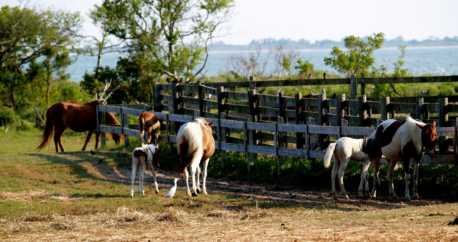
In the morning I took the dogs on a short hike to a small lake near our campsite. Once I was about 100 feet away from the campground I let the dogs loose and they had a ball running at full blast up and down the trail, after each other and past each other, and also exploring. I love them running free as much as they love being free.

A bit later all of us (dogs included) headed down to Lake George, nicknamed the Queen of American Lakes. In 1791, Thomas Jefferson wrote in a letter to his daughter, "Lake George is without comparison, the most beautiful water I ever saw; formed by a contour of mountains into a basin... finely interspersed with islands, its water limpid as crystal, and the mountain sides covered with rich groves... down to the water-edge: here and there precipices of rock to checker the scene and save it from monotony."

At one time, Lake George was one of the nation's first elite tourist destinations. Conveniently situated on the rail line halfway between New York City and Montreal, the lake became a magnet for the era's rich and famous by the late 19th and early 20th century. Tourists from all over North America and Europe flocked to Lake George and the surrounding majestic Adirondack Mountains. By the turn of the 19th century, Lake George was equaled only by Newport, Bar Harbor, Maine, Saratoga and the Hamptons as a summer enclave for America's aristocracy. Members of the Roosevelt, van Rensselaer, Vanderbilt, Rockefeller and Whitney families visited its shores.

Now, after 52 years, I was here again.

The town has become more of tourist trap than I remember it. This transition from enclave of the exclusive to schlock shops started about the time I was here last. In my opinion the transformation is now complete.

On a park in the middle of town was a craft fair. These are magnets for Marianne, and it is my duty to stop and stand by while she shops. And I did, but this time with the dogs along.

Molly walks on the leash like a dream, but isn’t the friendliest dog in the world, so she’ll bark when she’s approached by kids, but this time she did pretty well. Coco, on the other hand, is the total opposite; she tugs on her leash until she sounds like she’s choking. She also thinks that everybody is her friend, gladly stopping and jumping up on anyone who shows her any attention. It’s a funny scene, Coco licking the faces of kneeling strangers while Molly hides behind my legs. Molly really wants attention, too, especially if Coco is getting some, so she’ll come out of her shell, but she’ll bark if anyone moves too fast near her, startling everyone around her except Coco, who just keeps licking.

Driving further north I tried to find the place on the Lake where we stayed, but I didn’t remember where it was and as all other places I lived in over fifty years ago, the trees have altered the landscape, but I do think I saw a couple of likely candidates along on our drive.

We were headed to Fort Ticonderoga on Lake Champlain about 32 miles north of Lake George city. My family also visited this site half a century ago.

Just south of the fort is the charming little town of Ticonderoga where we stopped downtown to have lunch at the old-fashioned Burleigh House.

We continued past the fort entrance about a mile to where a little ferry crosses Lake Champlain to take travelers to Vermont. We had considered taking this route at one point.

We turned around and entered the fort grounds and all of a sudden came upon at least 100 tents surrounded by people dressed what appeared to be the period of the mid 18th century. We had fallen through a time warp and ended up in the middle of the French and Indian War.

This sort of thing happened to Marianne and I once before in our lives. In 1969 as we were driving in my Camaro from Yellowstone National Park, where we both worked and met, to meet my parents in South Dakota, I had the site of Custer’s Last Stand on my bucket list as an 18 year old.

Entering the national park, we saw about 50 cavalry troopers on horseback heading down a hill about ½ mile off of the road. At first we thought it was a mirage, and decided we wouldn’t tell anyone what we saw, believing folks would think us crazy.

We drove on, but about two minutes later we saw scores of Indians on horseback charging down another hill behind the troopers. We stopped the car again, and shot some pictures to prove we weren’t really crazy. Marianne suggested that this might be a reenactment, but I thought that this would be sacrilegious, having a massacre every two hours for the benefit of tourists, especially on hallowed ground in a national park.

We kept driving, and minutes later found ourselves on the movie set of “Little Big Man” the 1969 film starring Dustin Hoffman and Faye Dunaway. Although we didn’t see the stars, it was great coming upon the set late in afternoon as filming was wrapping up, and the troopers and Indians in their period outfits were getting on buses to return to their hotels.

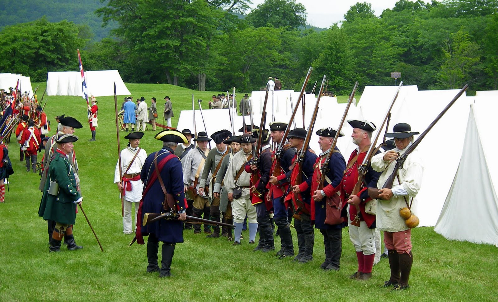
But today we weren’t on any movie set; instead this was a group of people from throughout New England and Canada who came here for the weekend to participate in the reenactment of the French and Indian War for three days, in what was in those days called Fort Carillon, existing just as the people of this era did, living in tents, eating food cooked on fires, and of course wearing period clothing. It was totally absorbing!

The name of the war refers to the two main enemies of the British: the royal French forces and the various Native American forces allied with them. The war was fought primarily along the frontiers between the British colonies from Virginia to Nova Scotia.

The war in North America officially ended with the signing of the Treaty of Paris on February 10, 1763, and war in the European theatre of the Seven Years' War was settled by the Treaty of Hubertusburg on February 15, 1763. The British offered France a choice of either its North American possessions east of the Mississippi or the Caribbean islands of Guadeloupe and Martinique, which had been occupied by the British. France chose to cede Canada, and was able to negotiate the retention of Saint Pierre and Miquelon, two small islands in the Gulf of St. Lawrence, and fishing rights in the area. The economic value of the Caribbean islands to France was greater than that of Canada because of their rich sugar crops, and they were easier to defend. The British, however, were happy to take New France, as defense was not an issue, and they already had many sources of sugar. Spain, which traded Florida to Britain to regain Cuba, also gained Louisiana, including New Orleans, from France in compensation for its losses.

We were only two tourists of what may have been a maximum of 100 tourists among at least 1000 re-enactors. While we were there, they were getting ready for their big battle scene, so folks were scurrying about get ready and into formations with their groups. Many of them were from the French speaking part of Canada, which was adorable when kids came up to the dogs to pet them, and were asking us stuff we just couldn’t understand. But I’d point to one and say Molly, point to the other and say Coco, and the kids understood. I think our dogs were the only “tourist” dogs on the site.

We didn’t purchase tickets to watch the big battle, but we caught glimpses of it from right next to the actual fort. We did, however, get to hear the constant firing of explosions from cannons and muskets, and smoke was rising in the air. What a treat!

On the way back to our campsite we decided to take the route that more or less was on the eastern shore of Lake George, when we came upon another charming town, Whitehall, located five miles west of the Vermont border at the south end of Lake Champlain and lying between Champlain and Lake George. The New York canal system ran through here, which made this an important town 200 years ago. During the Revolutionary War, General Philip Schuyler built a small fleet of ships here; they were used by Benedict Arnold in the Battle of Valcour Island, an event which led to Whitehall's modern-day claim to be the birthplace of the United States Navy. As a Navy veteran I didn’t even know this (imagine that!).

Whitehall is also home to Skene Manor, listed on the National Register of Historic Places as Judge Joseph Potter House, a handsome Victorian style mansion built of grey sandstone in 1874, sitting on a hillside overlooking the town.

Back at our campsite we caught up on our daily Internet chores, watched a little TV, before calling it a night.

June 25, 2010 – Day Forty-nine

We were on the west side of the Hudson River, and today I wanted to get on the east side, head up the gorgeous Hudson River Valley and end up in Lake George, where my family went for a week’s vacation in 1958. But there would also be a ton of history along the way.

We crossed the Hudson River at Poughkeepsie, and headed north. The next town was Hyde Park, home of Franklin Delano Roosevelt.

I had been to Warm Springs, Georgia, called the Little White House, twice to see the polio spa he saved and loved. Shortly before Germany surrendered, in the closing months of World War II, he was spending time there with his mistress Lucy Mercer, a woman he had known and loved for decades. She was the woman he promised his wife Eleanor that he would never see again when she found out about his affair with her earlier. Eleanor had never been to Warm Springs in the two decades of FDR’s visits, so he felt comfortable about having his trysts there. On the afternoon of April 12, Roosevelt said, "I have a terrific pain in the back of my head." He then slumped forward in his chair, unconscious, and was carried into his bedroom. The president's attending cardiologist, Dr. Howard Bruenn, diagnosed a massive cerebral hemorrhage (stroke). At 3:35 p.m. that day, Roosevelt died. At the time he collapsed, Roosevelt had been sitting for a portrait painting by the artist Elizabeth Shoumatoff, known as the famous Unfinished Portrait of FDR.

In the weeks earlier his blood pressure had been recorded at an astounding 330/180. He looked terrible, gaunt, and wasn’t his usual vigorous self. Boxer Jack Dempsey had once noted that his chest resembled that of a prize fighter.

But now we were in Hyde Park where FDR was born and where he was buried. And again we were able to use our Golden Eagle pass to be able to take a tour of the home for free.

The home overlooks the Hudson River, but the trees have grown as to practically obliterate the view. These trees were planted by FDR and on IRS documents he listed his occupation as tree farmer rather than lawyer.

As with TR, his fifth cousin, we learned much about his life including interesting tidbits of information that probably aren’t in any history books. This sort of information makes these presidents more like real people to me.

We continued north toward Lake George driving past one cute town after another. Someday I’ll have to come back this way with my Miata and in the fall when there is a color explosion.

One of the little towns we came through was Kinderhook, a name that seemed familiar to me for some reason. And it quickly became apparent to me when we drove by the birthplace, home, and burial site of this country’s eighth president, Martin Van Buren. Unfortunately there were no signs forewarning us of the site, so we regrettably sped on by. I made a mental note that this was now on my bucket list.

We passed through Albany, New York’s capital, and forty minutes later we were at the Lake George KOA.

Reading the literature regarding this KOA made me think it may have been on or even close to Lake George. But no, it was 8½ miles up the hill away from it, much closer to the much smaller Lake Lucerne. Oh well, live and learn.

We set up camp, and since we were in a somewhat remote area of the campground, and against regulations, we let the dogs loose. Immediately they began chasing each other at 90 miles per hour for about 10 minutes non-stop. It was fun watching them have such a blast. And when they were done, they were, you guessed it, dog tired.

Tonight we grilled some Bubba burgers on our outside grill. This was the first time on the trip we had used the grill, but it was now also finally becoming cool at night, cool enough to need a sweatshirt. Yea! No more killer heat for a while, because we were going to be heading even further north and toward the Atlantic.

Something to dream about.

June 24, 2010 – Day Forty-eight

We didn’t even try to make coffee today; we headed straight for a diner we drove by last night on the way to pizza. We wanted to compare diners. The Hauppauge Palace has the classic chrome and neon look, and it was good, but not as good as the previous day’s Ft. Dix Diner. This time the Eggs Benedict were only two eggs and it was a dollar more expensive. Maybe that’s the difference between Ft. Dix and Hauppauge.

After breakfast we headed back to the trailer to break camp and attack the Long Island highway system by skirting past the outskirts of New York City. By eating at the diner and taking our time, we were mostly able to avoid the crush of rush hour traffic heading into the City.

We were headed to White Plains to see if we could find the apartment building I lived in when my dad did his American internship in 1958. White Plains, part of Westchester County, has some fancy estate homes and is a world apart from the vertical jungle to its south. Early in the 20th century, White Plains' downtown area developed into a dominant suburban shopping district and featured branch stores of many famous New York-based department and specialty stores. Some of these retail locations were the first large scale suburban stores built in the United States. Today it is still a huge retail destination in the area with Bloomingdale's, Neiman Marcus, Nordstrom, Macy's, Sears, Wal-Mart, Kmart, Crate & Barrel, H&M, Burlington Coat Factory, and over 1000 other small and mid-size stores in four malls.

During the late 1960s, the city of White Plains developed an extensive urban renewal plan for residential, commercial and mixed-use redevelopment that effectively called for the demolition of its entire central business district. My apartment building was demolished to make room for the expansion of White Plains Hospital.

Driving through these city streets wasn’t that easy with my truck and trailer, but I decided to try to find Post Avenue School, my old grade school. It too was gone, replaced by a modern new school. My history was erased from the physical White Plains but not from my memories.

Marianne had never been to Connecticut so we made a small detour toward Danbury, stopping at the state’s visitor center along the Interstate, just as a large, dark ominous cloud was menacingly approaching from the northwest. We stopped to walk the dogs and have lunch inside the trailer, and within minutes we were in a rain deluge.

After 20 minutes it was all over.

That night on the TV news we heard that the storm had uprooted trees in Connecticut, and dropped 1” diameter hail on the Trogs Neck Bridge we had just crossed an hour earlier! And the wind was also extremely powerful on Long Island with tornado-like force near where we were camping. We were worried about the three girls that had set up a tent just across from our campsite in Blydenburgh County Park. They needed some help setting up their tent properly and were going to spend the night in the park after their prom. They were probably gone getting ready for their prom when the storm hit, but I wonder if there was anything left at their campsite when they got back.

We continued north to Plattekill, home to the KOA which claims as being the “New York City North KOA”. They even offer guided tours to all of New York’s tourist attractions, but I was guessing it would take at least couple of hours to get there and another couple hours to get back. It’s like my home town of Oceanside claiming to be the “South Los Angeles KOA” since it also takes two hours of travel time to get there.

This KOA could claim itself as the “Newburgh North KOA” since it’s only a few miles away from the home of Orange County Choppers, the Discovery Channel’s popular show about the dysfunctional family which built custom motorcycles. Their “World Headquarters” didn’t make in onto my current bucket list. Maybe in another life.

The Plattekill KOA is pretty much in the middle of nowhere down some two lane country roads on the west side of the Hudson River Valley. The area was settled in 1678 by the Huguenots, just 20 years after the failed English Lost Colony on Roanoke Island. Their homes in the small town of New Paltz, just a few miles north of the KOA, are some of the best examples of early stone houses built by Europeans in North America. It is also home to the State University of New York at New Paltz.

We also found a cute and very modern supermarket where we once again loaded up on supplies.

We did our Internet thing for a while and then got ready to climb into bed. The latest thing is that the dogs like to sleep on our bed just before we do, hoping against hope that their cuteness will allow them to stay. But I have developed a better method for getting the dogs off our bed, I just go to the jar where their treats are, open it, and they come bounding, sitting properly, begging for their treat. While they’re munching away, I sneak back into the bedroom, close the door and pass out.

June 23, 2010 - Day Forty-seven

Sometimes a day just doesn’t start out right, and you can wish that things only get better rather than worse.

Today was such a day.

Because Blydenburgh County Park has no hook-ups other than water, we couldn’t use our electric coffee maker. Yes, things are rough – it is camping after all. Instead, we use a coffee maker which looks like an electric coffee maker but sits on top of a stove burner for its heat source. It normally works, but it takes over 20 minutes to brew ten cups.

It also has a flaw – when the spout of the carafe doesn’t depress a lever, the hot water doesn’t flow. Well maybe it isn’t a flaw; it’s supposedly a feature – allowing one to remove it, by cutting off the brew flow so one can sneak a cup of coffee before the entire process is complete. Putting the carafe back makes the flow continue again. So much for today’s science lesson.

Now back at the point. As the coffee was brewing, the carafe’s spout was not depressing the lever, so the brew chamber overflowed. Coffee and grounds were erupting all over. Yuk, not only a mess, but it would take another 20 minutes to make another batch.

Marianne wisely suggested we go out for breakfast. And I knew the perfect place to get such a meal on Long Island – an authentic diner!

Off we went in search for that perfect diner. If you’ve ever spent any time in this neck of the woods you know when you’ve found such a place. It has to be made of neon and chrome and resemble a railroad car.

We ended up driving about 10 miles until we found such a place – the Ft. Dix Diner. It looked perfect, and the parking lot was fairly full, a good sign. I had Eggs Benedict, with three eggs for only $8.25. A deal – and it was delicious.

After breakfast I decided to find the first house I ever lived in when I immigrated to this country in the fall of 1955. Heck Ft. Dix was at least halfway there!

I put 32 Gates Avenue into the GPS and it came up with the most direct route. But that route wasn’t going to work for me because of the 7’ 10” height limitation of the roads the GPS wanted me to take. I now needed to use the compass in my head to get us in the right direction before the GPS could take over again.

Unfortunately after five decades, the compass in my head was a little rusty, so it took a little longer than it should have, but we finally found it, avoiding all of those vertically challenging roads.

About 9am we parked in front of the house. The neighborhood looked great, most of the houses had been modernized, but the biggest change was the trees. When I moved there over 50 years ago the trees were seedlings or plants that were held erect with stakes and twine. Now they were big, really mature, and throwing real shadows, as were some of hedges and shrubs. Also the modernization of the house included eliminated the green shingles on top half of the split level as well as the pink equivalent on the house next door.

As I approached the home to ring the door bell, a woman got into her car to back  outof the driveway. When I knocked on her car window, I slightly startled her but I convinced her to roll down her window. I identified myself as having lived in the home 55 years ago. That warmed her up. We chatted a bit, including her telling me that they were only the third owners of the house having lived there over 30 years, but she was in a hurry to get somewhere so she invited me to come back after 5pm to meet with her husband, who supposedly would love to meet us.

She left, and we continued walking around the neighborhood, then the couple next door came out of their house to see why this big pick-up truck with kayaks on the top had stopped in front of their home. He was on his way to work, but she stayed on the front lawn and filled us in with a quick history of the neighborhood, since they have lived in the house for 28 years, and absolutely loved the area.

My old house was immediately next to a school yard, Bethpage Elementary School, the first school I ever attended. I still remember the first day my mother literally had to drag me the couple of hundred yards to the principal’s office to enroll me in kindergarten. I begged her and begged her not to make me go because I didn’t speak English, only German.

Using the total immersion method before it even had a name, I was rapidly assimilated into the American way of life. My classmates even brought me to their homes to show off the German kid. One mother offered me a peanut butter and jelly sandwich for an after school snack, and she was totally amazed that I’d never heard of such a thing. I loved it, and when I got home I told me mom to buy peanut butter, Skippy brand, the next time she went to the supermarket.

Shortly after we moved it, a new school, Pine Avenue School, was built immediately adjacent to Bethpage Elementary, and when it opened, I attended it. I had stopped by the old neighborhood on my 1971 trip around the U.S. and both schools were still there, but now only Pine Avenue remained. According to the neighbor, Bethpage stood empty for about 15 of years, a deteriorating hulk before it was ultimately torn down.

After enough photos, we returned to the campground to pick-up the dogs and head to one of my favorite places on Long Island, Sagamore Hill, the home of Theodore Roosevelt. He hated being called “Teddy”, preferred “Colonel” instead. I had visited the home in Oyster Bay, only a few miles north of our Long Island house, in 1958 with my family, drove by in 1971 when it was too early to be open, then again in 1998 while I was teaching in northern New Jersey. But this was the first time Marianne had ever been here.

I have to admit that I have a yearning to see presidential homes, I’ve been to quite a few, and I would add a least a couple more on this trip that I’d never been to before.

We left the dogs in the truck while we took a tour of the house. This home has two distinguishing features to me, one it is dark inside, dominated by dark wood paneling, and in order to preserve its historical value, the windows shades are all halfway drawn blocking the rays of most of the illuminating light; and two, there are animal heads, hides, and tusks just about everywhere.

From here we headed about 20 miles east to Flushing, NY, near Kissena Park to find my old home on Oak Avenue. I didn’t remember the actual house number and when I called my mom she didn’t either, so we just cruised up and down the street a few times snapping photographs of the most likely candidates. This neighborhood, too, had changed, almost everyone appeared to be Asian. And of course the houses have changed in appearance with different paint schemes, add-ons, bay windows, and of course, bigger trees and shrubs.

Returning to the campground we made another stop at 32 Gates Ave. since it was a quarter past five. I knocked on the door, but sadly there was no answer. I missed an opportunity to see the inside of the house. As we were leaving, after taking yet more photos, the next door neighbor came out and greeted us again. We chatted for a couple of minutes before she left to visit another one of her neighbors.  When we left, we saw her sitting with her neighbor on that home’s front steps.

Back at the campground we took the dogs to one of only two off-leash dog parks in all of Long Island and it's right here in Blydenburgh. It's extremely popular and has two large sites, one for dogs smaller than 25 lbs. and one for larger dogs. Our dogs finally got the opportunity to mingle with East coast dogs. Molly and Coco weren't all that impressed, they spent most of their time checking out pMail and playing with each other. I particularly like this photo of Coco being chased (and apparently nipped in the butt!).

We craved for the best pizza in the area, and our camp hosts recommended a place called Umberto’s, about 8 miles east of us. They didn’t have the actual address, but it was easy enough to find.

Umberto’s was packed on a Thursday evening indicating that this was a great place. It was. Pizza-by-the-slice was the order of the day; we each had a slice of mergherita and a slice of Sicilian pizza plus a huge dinner salad, all for about $20. We received our order within a couple of minutes, and boy, was it delicious. Our camp hosts picked it right! And once again our diets were put on temporary hold.

We got back to the trailer with the generator still keeping the a/c cool for the dogs, and still enough time to keep it cool before we turned in for the night.

June 22, 2010 – Day Forty-six

This was a day I was dreading ever since I planned this trip – driving from New Jersey to Long Island, because I would have to navigate through New York City traffic.

There just aren’t that many places to camp with an RV in the middle of Long Island that I could find. I had to do a thorough Internet search to come up with a site, but none of them gave a specific address. For example, Blydenburgh is just listed as on the Veteran’s Memorial Highway in Smithtown. I guess if you live in the area that’s all you need to know. But a guy with 25’ long truck pulling a 30’ trailer needs to know a wee bit more.

The first number I called to try to make a reservation turned out to be the county parks and recreation department, which gave me a second number, which turned out to be the phone number of the park, but not the manager of the campsite. The third number was the charm.

When I checked into the availability of a campsite at Blydenburgh County Park in Smithfield, I was informed that the campground does not take reservations: first come first served. This alarmed be, especially since I was driving all the way through NYC to get there, and the availability of any other campgrounds in the area was apparently non-existent.

But have no fear, I was told, since I would be coming during a weekday, and the park currently had only five sites occupied. Just come on in. I was so excited that I forgot to ask for the park’s specific address.

I was informed that I should take the George Washington Bridge route, around the northern boundary of the City to get to Long Island, since driving a travel trailer close to the city was practically unheard of.

We’ll, I trusted that my GPS programs would guide me safely.

It turns out the GPS gods may have a sense of humor. A twisted sense of humor.

Leaving New Jersey, the GPS instructed me across Staten Island and then the Verrazano-Narrows Bridge, ending up in Brooklyn, where the freeway was under repair and I was forced to drive the truck and trailer on city streets, underneath the ailing interstate.

Marianne thought this was great, shooting photos out of the window in rapid succession, capturing details that were only blurs on my retina. I was tense, and getting a bad headache because people in New York drive like crazy – abruptly changing lanes and cutting me off, running red lights, blocking lanes by random parking, and worst of all, speed limits are only to be used as a minimal guide. Fortunately Marianne had some Ibuprofen for my pain.

I do however remember across the East River and seeing Wall St., and Manhattan as we went under the Brooklyn Bridge. When we finally got back on the Interstate, traffic was moving at a snail’s pace. I kept looking for just one other RV, but I never saw one. Not one – except when we finally reached the campground. Not for the entire time I was driving on Long Island, almost 200 miles over three days did I see any other RV on any of the roads I was on.

Oh, it doesn’t help that I couldn’t go on many of the roads that would have made the route a bit shorter. That’s because many of the roads have a height limit of 7’10”, my trailer is 10’6”, and the truck alone without the kayaks on top is 6’4”. I’m guessing that the kayak rack and the kayaks add at least another 18” to truck height, so I was right at that 7’10” mark, which I certainly didn’t want to risk. I went well out of my way to avoid those height limitations.

Since I didn’t have the actual street address of the Blydenburgh County Park, I had to guessimate where it was, but armed with that knowledge my GPS kept insisting I take those vertically challenged roads. I knew better, but there’s no sense in arguing with the voice on the GPS that insists I take the next right, then complains I’m off route, and wants me to take the next right, and when I don’t, I’m off route again.

And so it goes, until I finally turned it off, and used a different GPS program, one that is meant expressly for locating campgrounds. It could found the campground, but it doesn’t plot the road to get there. I could see where I needed to go, where I was, and what road I was travelling on, but not exactly how to get there. I had to trust my instincts.

These are now instincts dulled by Ibuprofen – better living through chemistry.

After fighting traffic for two hours on something called the Long Island Expressway – it’s long, it’s an island, but it isn’t an expressway, it’s slow, we made it to our exit, now we had to find the actual park.

My first guess turned out to be wrong, because I drove into the area’s huge police compound. At least I didn’t have to try to turn the truck and trailer around, there was a way out of this mess without doing that. I’m sure the people in the buildings were looking out of their windows wondering what the heck I was doing in their area. I didn’t want to guess what they were really thinking.

It turned out I turned one street too soon.

After getting back on track, we found the park entrance. In case you don’t know, I have to let you know that Long Island is a very populated place and to find a forested oasis in the middle of such an urban jungle is a treat. Blydenburgh Country Park is a treat.

This park has 648 acres of woodlands with a 100 acre lake smack in the middle of it. The entrance is guarded by a special park police building and the gates are closed from sundown to sunup. I counted three park police cars at the entrance.

After driving ½ mile into the park through a canopy of trees, I was finally at the campground entrance. When I checked in the man behind the counter commented that I was out of luck, because now there were seven campsites out of fifty in use, instead of the five he mentioned previously during our phone call.

We got to drive around the park and find the campsite we wanted, and we picked one in the extreme southeast corner, away from everyone, since we’d be using our generator during those hours it was allowed, because this park only offered a water connection. And did I mention it was still warm?

We got the campsite for two nights, unhooked the truck and trailer, and fired up the generator so we could have air-conditioning.

We just relaxed in our air-conditioned comfort until 9pm when it was quiet time and time to turn off the generator. Afterwards we turned on all our battery operated fans, put a Wanda Sykes comedy DVD into the laptop with the 17” screen and proceeded to laugh our butts off. When it was over, we were really tired and just went to bed to the soothing sound of whirling fans.

June 21, 2010 – Day Forty-five

I was awakened by the dogs just before sunrise on the longest day of the year, and the first day of summer, so I grabbed my camera and headed to the water’s edge with the dogs pulling me on their leash.

Tom’s River Camp is on the southeastern tip of Chincoteague Island on an estuary overlooking Assateague Island and its lighthouse. It was a beautiful morning to shoot photos, calm, great lighting, and hardly a soul awake at this hour. Fishing docks jut out into the water and at this hour I let the dog run free on them. They were tentative at first, but within a minute, they were old salts running up and down the pier.

We were on a timetable this morning, because we had a ferry to catch at Lewes, Delaware that would take us to Cape May, New Jersey. When I booked our passage, the notice said we needed to be there 30 minutes before departure to check in.

Driving out of Chincoteague, I once again came upon the NASA facility that I saw when I drove in. I knew nothing about the NASA Wallops Facility, so I had to check it out on the Internet.

In 1945, NASA's predecessor agency, the National Advisory Committee for Aeronautics (NACA), established a rocket launch site on Wallops Island well before Florida’s Cape Canaveral. This site was designated the Pilotless Aircraft Research Station and conducted high-speed aerodynamic research to supplement wind tunnel and laboratory investigations into the problems of flight. Between 1959 and 1961, Project Mercury capsules were tested at Wallops in support of NASA's manned space flight program before astronauts were launched from the Cape. Two rhesus monkeys, Sam and Miss Sam, were sent aloft as pioneers for astronauts; both were recovered safely. In 1974, the name was changed to Wallops Flight Facility and in 1981, it became part of Goddard Space Flight Center in Greenbelt, Maryland.

If I didn’t have that ferry to catch, I would have liked to stop at its visitor center to check it out. Another thing I’ll have to leave for another time.

We left Virginia and drove through a portion of Maryland. I’d say it was a small portion, but Maryland is a small state. And then we drove through a portion of Delaware, an even smaller state to get the ferry terminal at Lewes.

We got here with 12 minutes to spare on our 30 minute arrival window. Just enough time to duck into the modern visitor center and buy a T-shirt to prove I was here. As I was paying for the T-shirt, the announcement came that all drivers and passengers needed to be in their vehicles because the ferry was preparing to load.

Within a few minutes we were in an orderly procession driving into the bowels of the ferry, guided by deckhands to make sure we were as close to the wall and the trailer in front of us as possible. We were one of four or five trailers that would be making this sea journey.

The trip across the Delaware Bay to Cape May, New Jersey takes 70 minutes and cost $80 for the trailer, one driver, and one passenger. The dogs ride free, and were allowed to go on deck, or anywhere on the ship, except for the food areas.

Once we were parked we walked up the flight of stairs to get to the deck. The dogs had never been on a ferry, much less any boat before, but they were troopers. Once the ferry got up to speed, they loved having the wind blow through their fur. Several other people took their dogs on deck. And in very short order, Molly and Coco quickly became old sea dogs!

The hour and ten minutes went by very quickly and before we knew it, we disembarked in New Jersey.

When I checked campsites in and around Cape May a day or so ago, they were all a bit pricey so I kept looking until I found one called Cold Spring. When I checked it out on the Internet, it claimed to be a quaint old campground, dedicated mostly to seasonal campers, but with a few sites available for overnighters.

I called the number listed and was told, sure come on in, sites were available for only $31. Best of all it was on the opposite side of the canal near the site of the ferry terminal.

We drove the short distance to cross a bridge to get there, and once we got to the entrance of the park, we almost missed it because the sign was largely overgrown with bushes. And the entrance was extremely narrow, we had to avoid that sign and smash those bushes while turning down the one lane path in an attempt to find the office.

After a couple of hundred yards we came upon a house, but there was no indication that this was an office and there was no one home. Across from the house was the trailer from Desi and Lucy’s movie, “The Long, Long Trailer”. This was starting to look eerier and eerier.

I found an elderly resident of the park inside the screen porch of his permanently planted travel trailer, and he informed me that the office was another couple of hundred yards down the overgrown path. I was leery of driving down this path with the truck and trailer for fear that I wouldn’t find a place to turn around, so I moved the trailer over as far to the side of the lane as I could and headed down the path to see what I could find.

I found the office but there wasno one was around. Taped to the door was a note that said Mr. Mueller should take the campsite called “walnut”. A walked a bit more, found the site, and determined that after some finagling I could fit my trailer into the little site. I returned to the truck and pulled the trailer further into the woods and with Marianne’s able assistance was able to back into the site.

The campground was extremely secluded to say the very least, most of the trailers stood empty waiting with rotted tires for their weekend residents. There may have been one other trailer that wasn’t permanent in the entire park. But we did have water, electricity, and sewer, and our antenna pulled in more than enough TV channels.

I had been to Cape May in 1998 when I was working for AESA, based out of San Diego. This outfit hired computer nerds like me to teach employees of Bell Atlantic an entry level computer technician course, since they were going to be laid off soon and this was part of the transition process. I flew into Newark four times, two of those times to teach in the little town of Mamora which is just a few miles north of Cape May.

On a day that I had off, I drove my rental car to Cape May to see the cute downtown shopping area, the Victorian mansions overlooking the Atlantic, and its marquee lighthouse. I didn’t spend much time in the shopping district but vowed that one day I’d bring Marianne here to see it.

That one day became today.

We drove the short distance into Cape May, saw the folks on the beach with their umbrellas, saw the large Victorian style homes and hotels, and then went to the city center shopping district where cars are banned. Marianne had a grand time checking out many of the stores, and we even bought some gifts! We also found an Italian gelato store, so we just had to have a lemon ice!

Hermit crabs are also a popular item in the novelty stores. If you buy the cage, accoutrements, and food, you’ll get your crab for free. I noticed that about 100 of these crabs together in their “for sale cages” stink. And then I wonder how long these little guys last once they’re brought home and forgotten.

With the sun waning on this summer solstice day, we headed back to the trailer (hoping we could find the place again), had dinner, watched some TV and called it a night.

June 20, 2010 – Day Forty-four

According to my GPS’s to get to Chincoteague Island, Virginia I have to go south from Williamsburg, go under a tunnel and across a very long bridge near Virginia Beach. I knew that.

But my inner instincts kicked in when we left the Williamsburg KOA and I just naturally headed north. We were immediately stuck in a traffic jam and progress was slow.

After a bit I checked the GPS and it said we had about 300 miles to go!

What???

That’s twice as far as it should be. And then I remembered…south, and then north. We turned around and by the time we got back to our original exit we had lost about an hour’s worth of time.

This was the second time we went through the tunnel near Hampton Roads, where Navy ships dot the horizon and ships of all sizes plow through the water. The first time was a three days ago when we came up here from Kitty Hawk. This tunnel passes under the James River where it empties into the Chesapeake Bay.

And after going through the tunnel we finally headed north crossing a bridge across the mouth of the Chesapeake Bay that’s over 18 miles long. Shades of Key West again.

Our dogs now go to sleep almost instantly when we put them into the truck for the day’s drive. They snooze contently on their oversized pillow that takes up two-thirds of the back seat, not even batting an eyelash when we cross rough, bumpy roads. This has become their way of life. I wonder how they’ll adjust when we get home again.

I headed to Chincoteague Island because of a book I read when I was about 12 or 13 called “Misty of Chincoteague Island”, Marguerite Henry's famous children's novel that tells of a young brother and sister that grew up on Chincoteague Island. They attended the pony swim event and purchased an Assateague wild pony they referred to as "Misty". The children raised money to buy Misty by harvesting clams, which is still a source of income for some Chincoteague residents today. Misty was unique in that she had the markings of a map of the United States on her side. Later in life, Misty lived with Marguerite Henry while Marguerite wrote the book. A Hollywood movie called "Misty" was made which featured the Chincoteague Pony Swim and many residents of Chincoteague Island appeared in that movie.

We had made reservations to stay on Assateague Island where the ponies actually roam free, it’s a national seashore, but the camping is dry camping – no electricity, water or sewage. And since it was still hot we’d have to rely on our generator for air-conditioning, and generator hours are always limited. So we checked on an alternative site on Chincoteague proper.

We drove through Chincoteague to get to Assateague which is a barrier island. But when we got to the park entrance there was a sign that said not pets allowed, not even in cars. The information on the website said that pets were allowed on the campsites.

When I told them that I had a reservation for the campsite, I was kindly told that camping was 90 minutes north of here, and that part of Assateague Island was only accessible via Maryland, near the resort city of Ocean City.

We didn’t feel like driving that much further so we turned around and checked into Tom’s River Campground, which was a huge campground predominately occupied by folks who leave their RV’s there permanently for the season. It was overrun by families.

I was given A-12 as a site, but when I got there, a pick-up truck was in the site, and that’s about all that would fit into it. A couple of the local yokels were out front jawing and when they saw me, they said that no one had camped in this small spot all season. So, I decided to just grab an adjacent site that I could fit into.

After I backed in, I noticed that all the utilities were centrally located so that four RV sites would be able to access them. Fortunately for me, I had extensions for my power and water hose, but they were almost stretched to the limit. My 25’ TV cable connection was the only thing close to the utilities since it is mounted on the back edge of the trailer.

We got everything set-up and I unloaded the bicycles and we drove to the camp office to let them know that we had changed sites. The office is the front of a large camp store, one of the larger ones we’ve encountered. Not only can you find a limited selection of groceries, T-shirts, swimming gear, and knick knacks, but also an extensive selection of fishing gear. I see where these peoples’ priorities are.
 
We left the dogs in the trailer and drove back to Assateague Island to view the wildlife, hoping to catch a glimpse of a pony or two. There’s a figure eight road that runs about five miles through this part of the island’s marshes. It appeared that most of the people there were birdwatchers, since there are many different kinds enjoying the wilderness here.

There are bicycle and hiking trails throughout as well, but we were warned that if we didn’t have a liberal amount of bug repellent on us, we’d be eaten alive. So we mostly stayed in the car, shooting our photos from the protection of the truck cab.

We found no ponies roaming free, but Chincoteague’s volunteer fire department has a few ponies penned up not too far from the road, so I was at least able to get a pony photo.

I did, however, get out of the car to photograph what I believe was a snowy egret catch fish. Nearby was a very dedicated birdwatcher with her camera mounted on a tripod. I just walked up there snapped a half dozen shots and got back into my truck.

The sun was starting to set across our shoulder as we got the eastern edge of the island which serves as the area’s main beach to the Atlantic Ocean. The Atlantic shoreline is definitely different than the coastline back in North San Diego County, and so far, I like my California coast better.

We drove up and down the ½ mile stretch of beach as folks were heading back to their cars, calling it a day. As we left the beach area we came upon that same lady with her camera firmly on the tripod, still stalking that same bird. That’s a dedicated birdwatcher.

Heading back into town there was a McDonald’s which was beckoning me with its siren call. We hadn’t eaten lunch so I couldn’t resist. Yet here next to their parking lot was another pony pen with a half dozen horses which one could reach out and pet.

Back at the campsite, we watched a little TV, caught up on our Internet duties, and turned in for the night, another full day.

June 19, 2010 – Day Forty-three


The Williamsburg KOA hosted a free pancake breakfast today. I love pancakes and I love free food! But out of the goodness of my heart I donated $5 toward the cause, whatever it may have been.


Today, Yorktown, Virginia was in our sites.

The Siege of Yorktown or Battle of Yorktown in the fall of 1781 was a decisive victory by the combined assault of American forces led by Major General George Washington and French forces led by General Comte de Rochambeau over a British Army commanded by Lieutenant General Lord Cornwallis. It proved to be the last major land battle of the American Revolutionary War, as the surrender of Cornwallis's army prompted the British government eventually to negotiate an end to the conflict.

Williamsburg, Yorktown, and Jamestown are all very close to each other. This entire area is richly steeped in American history and we could have spent much more time here, even driving to Charlottesville, Virginia to see Thomas Jefferson’s Monticello, but we have to save some things for another odyssey, this one during the fall foliage explosion.

Negotiating the maze of roads we finally made it to the Yorktown waterfront. This completely rebuilt area was host to a farmer’s market today. I would have enjoyed it more but it was still so damn hot.

From here we headed to the site of the Yorktown battlefield, a national park. Once again my Golden Eagle pass got us in without paying. The visitor center offers a museum with battlefield artifacts, a mock-up of an 18th century sailing vessel, an assortment of dioramas depicting the siege, and a movie explaining each side’s strategy.

The trenches marking the offensive and defensive siege lines were uncovered by black conservation corps members during the Depression. Also, a host of cannons are within walking distance, some original, some replicas, all interesting.

But best of all was the firing of one of the replica cannons by troops dressed in period pieces. It almost made me feel as if I was in the area 225 years ago.

Returning to the trailer took a lot longer that it should have, because the GPS said one way, Marianne said another, and the road marked “west” really went east. Aggravating, to say the least.

After a rest from the morning’s Yorktown visit, we headed to the local Wal*Mart for resupplies. We also bought a several non-essential items, like a new book on CD (Laura Bush’s book), so we ended up sending spent close to $200.

That evening I decided to go to the pool to cool off. I should have known better. This campground is a haven for families, and the pool was crowded, including babies in diapers. The deep end of the pool was only 5’, but one couldn’t see the bottom. So I just hung my legs over the edge and watched the show.

Back at the trailer we had a late dinner, turned on the TV, but spent most of our time working on our photos and on the Internet catching up on email and this blog. It’s almost like being at home: Marianne on her computer and me on mine. We couldn’t imagine this trip without our computers and the Internet.

June 18, 2010 - Day Forty-two

Today marks six weeks on the road, and we haven’t killed each other or the dogs yet, or vice versa.

On our agenda today was a visit to Colonial Williamsburg, the historic district of the independent city of Williamsburg, Virginia. It has buildings dating from 1699 to 1780 which made colonial Virginia's capital. For most of the 18th century, Williamsburg was the center of government, education and culture in the Colony of Virginia. George Washington, Thomas Jefferson, Patrick Henry, James Monroe, James Madison, and others molded democracy in the Commonwealth of Virginia and the United States here.

We found a parking spot at the huge visitor’s center, and the evening before had learned from the West Virginia fishing couple that one needn’t pay for admission as long as one walked and didn’t go into any the museums or exhibits. This would be perfect for us.

So off we went, leaving the visitor’s center on foot headed back into a time warp. We thought it would start just beyond the bridge that the left the center, but no….we had to walk about a mile to get into the actual area. And it was still hot.

We entered the town and yes, it was 18th century America, but it had sort of Disneyland effect on me, without the rides or Mickey. The buildings were immaculate and people dressed in period clothing where driving and riding horses, which pooped all over the streets, affording a true period aroma.

We only had two hours to visit this huge area, so we only saw a small part of it. People were telling us we had to spend two days here to see everything, that was more time than I wanted to spend here, nor did I want to spend $150 for a two-day pass.

Since it was lunch time and we were getting hungry, we headed to their equivalent of restaurant row, choosing a tavern to quench our desires. As we headed to the street where the tavern was located, we were blocked by a rope across the road and young woman dressed in a period outfit asking to see our tickets. We had none, and with that we were banned from entering since there was some sort of show going on further up the street that only paying guests could witness. She did tell us a back way to get to the tavern via an alley. The sign on the back door directed us to the front door, which now put us where we were banned just minutes ago. Oh well, live and eat.

At the door we were greeted by three people, again in period dress, and promptly escorted to our table which was in the basement of the tavern lit by candles. Marianne had a hard time reading her menu in the dim lights, so my trusty LED pocket light came to the rescue. Marianne ordered the equivalent of a cheeseburger and fries, and I had a Virginia ham sandwich, with a crawfish soup appetizer. All the food was scrumptious.

After lunch we retraced our steps back to the truck, stopping but once in an open air period market selling an assortment of trinkets, including the popular three edged hat, which was donned by more than one tourist.

It turns out that the highlight of our visit to the town was the 1957, 45-minute movie shown at the visitor’s center, about Colonial Williamsburg at the time immediately before the signing of the Declaration of Independence, starring a young Jack Lord, of Hawaii Five-O fame.

We came back to the trailer, dead tired from all the walking and the heat. We rested up a bit until we conquered our next challenge that evening, washing clothes.

The laundermat at this KOA was again within walking distance of our trailer, but since we had too much laundry to easily carry we drove the truck over there. And for some godforsaken reason, the laundry was not air-conditioned. So not only was it hot outside, it was doubly hot compliments of the commercial-sized driers.

We just put our clothes into two washers, stuck in our $2 each and walked back to our trailer, leaving the truck. Thirty minutes later I walked back, put the clothes into two driers, paid $1.50 for the drying and returned to the trailer. Another thirty minutes later we returned to retrieve our clothes, but by now the lights had gone off in the laundry room and rather than put more money into the driers and wait in the heat and dark until the clothes were dry, we removed our still damp laundry, loaded it into the truck and drove back to the trailer.

We had to hang and spread our laundry all over the trailer in order for it to dry. It would end up taking 24 hours before the clothes was dry enough to accomplish this feat, compliments of the high humidity in the area.

After all of this, we just fell into bed.

June 17, 2010 – Day Forty-one


We packed up yet once again and this time we were headed to Kitty Hawk, home to the Wright Brothers memorial. I was amazed to learn that the site of the birthplace of aviation is just a couple of miles as the crow flies from the site of the Lost Colony. That’s never explained in any history books. We however had to drive about ten miles since we had to cross another bridge from Manteo on Roanoke Island to Nags Head on the Outer Banks and then drive a few miles north.

We drove right by the Wright Memorial because we were in the wrong lane and I didn’t see any signs announcing it. We were in the right lane and the memorial was off on the left. You’d think the Wright Memorial would be on the right side, right? A couple of hundred feet past the entrance I was able to make a right turn, driving once around a block until we were back on the main road, took a left, and finally make that right turn into the Wright Memorial. This was a federal monument and as such we were able to use our Golden Eagle Park Pass to get in for free, sort of, since I had to buy the pass a few months ago, but it did save me at least $20 today.

This park is basically a ½ mile long by ¼ mile wide meadow with a 75’ hill on the south end, topped by an obelisk dedicated to the historic event. When the Wright brothers flew on that fateful December 13, 1903 they were taking off to the north, into the direction of the winter winds. They made four flights that day, each one a little longer than the previous one. The last one ended up in a crash landing that damaged their flyer beyond repair. The next day they packed up and went home to Dayton, Ohio.

There is a visitor’s center with a couple of exact size replicas of the flyer as well as dioramas of the event. Also on the grounds is a museum, which seems to be sponsored by the aviation industry, complete with another replica, and a movie theater which continually shows the story of what happened here just over 100 years ago.

I walked the entire grounds, Marianne bowed out of this, since it was still hot. Fortunately there was a stiff breeze blowing which helped. When I returned from visiting the obelisk memorial, there were 25 kids flying kites near where the brothers launched their contraption.

From here we drove to Williamsburg, Virginia site of the recreated first capital of the state. We booked ourselves into the local KOA for two nights so that we would have time to thoroughly enjoy the area, as well as time to wash clothes.

That evening the campground had a candy bar bingo event. After much searching we found the pavilion where it was located. This well-shaded campground it huge, so huge it is divided into two different parks. The instructions told us to go to one of the two parks, but when we got there we found it was in the pavilion in our part of the park.

It was so hot in that un-air-conditioned building, and we were only playing for Halloween candy, so after about a half dozen games Marianne and I decided to go exploring and buy our own candy bars.

We aimlessly drove around the wooded countryside until we came upon a sign directing us to a fishing pier. After driving a few miles under the canopy of trees in the dusk, following the trail of lightening buds, be came upon a clearing that was part of a state park just in time to see the sunset. As a couple of the last fishermen were loading up their boats, we walked out onto the 100’ long fishing pier. At the end of the pier was a couple about our age, visiting from West Virginia, casting their fishing lines a few more times before they had to quit because the park closed at 9pm. They offered to share their bait with us, but we declined, since we were more interested on what they could tell us about the area. They were loquacious.

As we pulled out of the park the “need fuel” light came on, and since we didn’t know exactly where we were, we had to go hunting for diesel. The first two stations we found didn’t have diesel. At the second we were directed to a third “up the road a piece” only to discover it was closed for the night. But next door was a mini-market so we were finally able to get our candy bars.

We turned around with the aid of a GPS we headed back to the campground, coming upon a Shell station with diesel a short time later. With fuel in the truck we made it back, walked the dogs and went to bed.

June 16, 2010 - Day Forty

Forty days! And coming up on 40 nights!

Just as I was waking up, I heard the pitter patter of rain sprinkles on the roof of our trailer. Now, I’m not worried about rain on the trailer; I’m just worried about having to take the dogs out on their morning constitutional walk in the rain. They get wet, dirty, and then stinky, not only that, they aren’t too excited about doing their business when it’s raining.

Lucky for all of us the rain stopped after only about a half hour. But the ground was still wet so they got wet and stinky anyway.

The young couple in the tent was packing up and leaving early. We’re not as motivated, so it took us a few hours to drink our coffee, have breakfast, do our Internet bit, and finally pack up the trailer, hook it up and get ready to go. The luxury of retirement and no time commitments!

We plotted our course for the Outer Banks of North Carolina, 150 miles away. We didn’t have any place to stay, but we weren’t too worried because it wasn’t a weekend.

When we were about 70 miles out, we stopped at a visitor’s center in Plymouth, North Carolina and received a recommendation of where to stay. The Refuge on Roanoke Island had one opening left for only one night. We were in luck! We pressed on.

We had been driving through rain squalls on and off all day, and the final push to the Outer Banks was no different. These islands are connected to the mainland via bridges that reminded me of Key West.

Roanoke Island was the site of the first English colony in the New World. It was financed by Sir Walter Raleigh in 1585 settled in 1587, but by 1590 the inhabitants of the colony disappeared off the face of the earth, the only clue to their whereabouts was the word “Croatoan” carved into a tree, discovered by the crew a re-supply ship. No one knows for sure what happened to the colonists including Virginia Dare, the first English baby born in the New World. St. Augustine claims to be the birthplace of the first European in the New World.

Our campsite was closer to the southern end of the eight mile long island near the community of Manteo. The Refuge on Roanoke Island’s main office wasn’t too much larger than an outhouse, where Peggy, the manager, entered from her motorhome to welcome us in. The place was treeless since it was only about two years old. Its saving grace was that it was on a small pond that was part of the surrounding marshland. There were wooden boardwalks that allowed visitors to wander further into the marshes.

Nevertheless, we felt lucky to have found a place that offered full hook-ups and our site backed up right to the pond with only a sidewalk and a three-foot drop separating the trailer from the water. The drawback was that there are geese in this pond, and geese poop a lot, and it’s the size of dog poop. So our campground was a minefield of poop. Not only that, but our dogs found this stuff tasty. Yuck!

Later that afternoon we decided to visit the site of the famous settlement, called Fort Raleigh, on the northern end of Roanoke Island. We briefly stopped at the visitor center, learned everything we could in about 10 minutes. The most important thing we learned is that we needed to see the play “The Lost Colony”, which is presented almost nightly during the summer season, and has been since 1937. This makes it the longest running play in the United States. Andy Griffith performed in the play in the late ‘40’s and early ‘50’s. In fact he liked the community of Manteo, named after the Indian chief at the time of the Lost Colony, so much that he moved here.

We walked the 500 steps to the play’s ticket office and purchased two tickets for the 8pm show tonight; getting seats just 6 rows back from the stage.

Then we walked another 500 steps to the site of the colony, but in actuality there isn’t too much there, just a recreated seven-foot high ring of dirt about 70’ in diameter. Although it isn’t that impressive visually, it gave me an eerie feeling just being on such hallowed ground, very metaphysical.

We also stopped by the Elizabethan Gardens, checking out only the gift shop and not paying the admission to see another garden, especially after we’ve seen Bellingrath Gardens in Mobile.

We returned to the trailer just long enough to walk the dogs and eat dinner. Then we got back into the truck to head north and see the play. Within a mile of the campground it started raining very hard, sheets of rain, large puddles were forming at the side of road. Not good for seeing an outdoor play.

But as we approached the northern end of the island the rain had miraculously abated. We arrived a quarter to eight, fifteen minutes before the start of the play. From the parking lot we walked to the entrance, but were informed that the start of the play would be delayed because of lightening in the area.

When we purchased our tickets we were informed that if the play was interrupted due to rain with the first thirty minutes, we would be eligible for a full refund, by mail. While the crew was waiting for the lightening to subside, we milled under the covered entrance area. We waited and waited and waited.

Finally an hour after its supposed start, we were allowed into our seats. I was worried that I would be able to stay awake for the next two and a half hours and then still drive back to the trailer.

But my fears were allayed once the play started. The actors were great, the scenery was great, the effects were great and the costumes were great.  And the retort of guns would awaken any one who was foolish enough to try to sleep. Actors also appear on two stages to the right and left of the audience, as well as enter from the aisles. The scenery changed from 16th century London, to the ports, to the wilderness, to the colony itself. I thoroughly enjoyed the play, including the singing.

And we made it home shortly before midnight, tired but satisfied.